Quick Overview of the Manaslu Circuit Trek and Its Distance
| Feature | Details |
| Total Trekking Distance | 177 km (110 miles) |
| Standard Duration | 12 to 14 days |
| Highest Point | Larkya La Pass (5,106 m) |
| Average Daily Walking Time | 5 to 7 hours |
| Difficulty Level | Moderately Difficult |
The Manaslu Circuit Trek is a premier off-the-beaten-path journey in Nepal. It offers an incredible alternative to busier regions. You move from subtropical lowlands to high alpine terrain. The route follows the deep Budhi Gandaki River gorge before crossing into the Marsyangdi Valley.
Have Questions About Manaslu Trek Distance?
Wondering how far you will walk each day or whether the distance is manageable for your fitness level? Talk to our trekking team for guidance on daily walking hours, terrain, and altitude.
Manaslu Circuit Trek Distance by Itinerary Length
The total distance you walk each day depends directly on the number of days you spend on the trail. A shorter schedule means you must cover more ground per day. Meanwhile, a longer schedule distributes the kilometers evenly and gives your body more time to adapt. Choosing the right itinerary length directly affects your daily physical output and your safety at high altitudes.
9-Day Short Manaslu Circuit Trek Distance
Modern dirt roads have reshaped the trekking landscape in the Manaslu region. Jeep tracks now extend deep into the lower valleys, directly affecting both your starting point and final stops. By utilizing vehicle transport to bypass the dusty low-altitude road sections, a 9-Day Short Manaslu Circuit Trek becomes entirely possible. This shortcut considerably trims the traditional 177 km total down to a concise mountain path.

But this rapid route demands intense physical effort. You skip the slow, classic walking approach, meaning you must tackle much longer distances and higher elevation gains every single day. Meanwhile, your body gets fewer days to adapt naturally to the changing atmosphere. Because of the accelerated pace, this itinerary is designed for experienced trekkers with exceptional stamina and strong high-altitude experience.
| Day | Route | Start Altitude (m) | End Altitude (m) | Distance (km) | Walking Time | Difficulty |
|---|
| Day 1 | Drive from Kathmandu to Machha Khola | 1,400 m | 890 m | 160 km (Drive) | 8 – 9 hours | Moderate |
| Day 2 | Trek from Machha Khola to Jagat | 890 m | 1,410 m | 22 km | 6 – 7 hours | Strenuous |
| Day 3 | Trek from Jagat to Deng | 1,410 m | 1,804 m | 20 km | 7 – 8 hours | Strenuous |
| Day 4 | Trek from Deng to Namrung | 1,804 m | 2,630 m | 19 km | 6 – 7 hours | Strenuous |
| Day 5 | Trek from Namrung to Sama Gaon | 2,630 m | 3,520 m | 17 km | 5 – 6 hours | Moderately Hard |
| Day 6 | Trek from Sama Gaon to Samdo | 3,520 m | 3,875 m | 8 km | 4 – 5 hours | Moderate |
| Day 7 | Trek from Samdo to Dharmasala | 3,875 m | 4,460 m | 12 km | 4 – 5 hours | Moderately Hard |
| Day 8 | Cross Larkya La Pass to Bimthang | 4,460 m | 3,720 m | 24 km | 8 – 10 hours | Very Strenuous |
| Day 9 | Trek to Dharapani, drive to Besisahar/Kathmandu | 3,720 m | 1,860 m | 16 km (Walk) | 5 hours (Walk) | Moderate |
12-Day Manaslu Circuit Trek Distance
The 12 Day Manaslu Circuit Trek is a demanding alternative to busier Himalayan routes. You will walk through the narrow gorges of the Budhi Gandaki River and cross a high mountain pass. Fitness is mandatory for this short itinerary because it cuts out extra rest days.
| Day | Route | Start Altitude (m) | End Altitude (m) | Distance (km) | Walking Time | Difficulty |
|---|
| 1 | Kathmandu to Machha Khola | 1,400 m | 890 m | 160 km (Drive) | 6–7 hours | Gentle |
| 2 | Machha Khola to Jagat | 890 m | 1,410 m | 22 km | 8–9 hours | Moderate |
| 3 | Jagat to Deng | 1,410 m | 1,804 m | 20 km | 7–8 hours | Moderate |
| 4 | Deng to Namrung | 1,804 m | 2,630 m | 19 km | 6 hours | Moderate |
| 5 | Namrung to Lho Village | 2,630 m | 3,180 m | 11 km | 5 hours | Moderate |
| 6 | Lho Village to Sama Gaon | 3,180 m | 3,520 m | 16 km | 6 hours | Moderate |
| 7 | Rest Day at Sama Gaon | 3,520 m | 3,520 m | 0 km | 0 hours | Gentle |
| 8 | Sama Gaon to Samdo | 3,520 m | 3,875 m | 8 km | 3–4 hours | Moderate |
| 9 | Samdo to Dharmasala | 3,875 m | 4,460 m | 12 km | 4 hours | Challenging |
| 10 | Dharmasala to Bhimtang via Larkya La Pass | 4,460 m | 3,720 m | 24 km | 8–10 hours | Strenuous |
| 11 | Bhimtang to Tilije | 3,720 m | 2,300 m | 17 km | 6–7 hours | Moderate |
| 12 | Tilije to Besisahar and Kathmandu | 2,300 m | 1,400 m | 222 km (Drive) | 8–9 hours | Gentle |
14-Day Manaslu Circuit Trek Itinerary Distance

The 14-day Manaslu Circuit Trek delivers a rugged, high-altitude loop around the eighth-highest mountain in the world. This route requires excellent physical fitness. You will cross Larkya La Pass, which sits at an altitude where oxygen levels drop significantly. It is a challenging journey, but proper acclimatization makes it safe.
| Day | Route | Start Altitude (m) | End Altitude (m) | Distance (km) | Walking Time | Difficulty |
|---|
| 1 | Kathmandu to Machha Khola | 1,400 m | 890 m | 160 km (Drive) | 6–7 hours | Moderate |
| 2 | Machha Khola to Jagat | 890 m | 1,410 m | 22 km | 8–9 hours | Moderate |
| 3 | Jagat to Deng | 1,410 m | 1,804 m | 20 km | 7–8 hours | Moderate |
| 4 | Deng to Namrung | 1,804 m | 2,630 m | 19 km | 6 hours | Moderate |
| 5 | Namrung to Lho | 2,630 m | 3,180 m | 11 km | 4 hours | Moderate |
| 6 | Lho to Sama Gaon | 3,180 m | 3,520 m | 16 km | 4–5 hours | Moderate |
| 7 | Acclimatization Day in Sama Gaon | 3,520 m | 3,520 m | 0 km | 0 hours | Easy |
| 8 | Sama Gaon to Samdo | 3,520 m | 3,875 m | 8 km | 3–4 hours | Moderate |
| 9 | Acclimatization Day in Samdo | 3,875 m | 3,875 m | 0 km | 0 hours | Easy |
| 10 | Samdo to Dharmasala | 3,875 m | 4,460 m | 12 km | 4 hours | Moderate |
| 11 | Dharmasala to Bimthang via Larkya La | 4,460 m | 3,720 m | 24 km | 8–10 hours | Strenuous |
| 12 | Bimthang to Dharapani | 3,720 m | 1,860 m | 17 km | 6–7 hours | Moderate |
| 13 | Dharapani to Besisahar to Kathmandu | 1,860 m | 1,400 m | 222 km (Drive) | 8–9 hours | Moderate |
| 14 | Final Departure | 1,400 m | 1,400 m | 0 km | 0 hours | Easy |
Is the Manaslu Circuit Distance Right for You?
Understand the daily walking demands, changing terrain, and high-altitude sections before you trek. Explore the itinerary and prepare for the challenge ahead.
The Tsum Valley Trek Extension Distance
The Tsum Valley Manaslu Circuit Trek in Nepal is a demanding, high-altitude loop that takes you deep into a culturally isolated Buddhist valley before retracing your route around the mass of Mount Manaslu. This trek is physically taxing. You will spend multiple days at elevations where oxygen levels drop significantly, culminating in the grueling crossing of Larkya La Pass. You must prepare for long hours of walking on narrow rock paths, steep stone stairs, and raw glacial moraine. Special restricted-area permits are required for both the Tsum Valley and the Manaslu restricted area. Independent trekking is illegal here. But a solo trekker can legally complete this route with one mandatory licensed guide.
| Day | Route | Start Altitude (m) | End Altitude (m) | Distance (km) | Walking Time | Difficulty |
|---|
| 1 | Kathmandu to Machha Khola | 1,400 m | 890 m | 160 km (Drive) | 6–7 hours | Moderate |
| 2 | Machha Khola to Jagat | 890 m | 1,410 m | 22 km | 8–9 hours | Moderate |
| 3 | Jagat to Lokpa | 1,410 m | 2,240 m | 16 km | 6–7 hours | Moderate |
| 4 | Lokpa to Chumling | 2,240 m | 2,386 m | 11 km | 5–6 hours | Moderate |
| 5 | Chumling to Chhokangparo | 2,386 m | 3,010 m | 13 km | 5–6 hours | Moderate |
| 6 | Chhokangparo to Nile | 3,010 m | 3,361 m | 12 km | 4–5 hours | Moderate |
| 7 | Nile to Mu Gompa | 3,361 m | 3,700 m | 6 km | 3 hours | Moderate |
| 8 | Exploration Day at Mu Gompa | 3,700 m | 3,700 m | 0 km | 0 hours | Easy |
| 9 | Mu Gompa to Burgi Village via Milarepa Cave | 3,700 m | 3,240 m | 11 km | 5 hours | Moderate |
| 10 | Burgi Village to Chumling | 3,240 m | 2,386 m | 14 km | 6 hours | Moderate |
| 11 | Chumling to Deng | 2,386 m | 1,804 m | 18 km | 6–7 hours | Moderate |
| 12 | Deng to Namrung | 1,804 m | 2,630 m | 19 km | 6–7 hours | Moderate |
| 13 | Namrung to Sama Gaon | 2,630 m | 3,520 m | 17 km | 5–6 hours | Moderate |
| 14 | Acclimatization Day in Sama Gaon | 3,520 m | 3,520 m | 0 km | 0 hours | Easy |
| 15 | Sama Gaon to Samdo | 3,520 m | 3,875 m | 8 km | 3–4 hours | Moderate |
| 16 | Samdo to Dharmasala | 3,875 m | 4,460 m | 12 km | 4 hours | Moderate |
| 17 | Dharmasala to Bimthang via Larkya La | 4,460 m | 3,720 m | 24 km | 8–10 hours | Strenuous |
| 18 | Bimthang to Dharapani | 3,720 m | 1,860 m | 17 km | 6–7 hours | Moderate |
| 19 | Dharapani to Besisahar to Kathmandu | 1,860 m | 1,400 m | 222 km (Drive) | 8–9 hours | Moderate |
Duration:19 DaysStart fromUSD 1700USD 1533based on 5 reviews
Day-by-Day Manaslu Circuit Trek Distance Breakdown
Lower Manaslu Section: Soti Khola to Namrung
This opening stretch covers a massive portion of your overall trail mileage. You will follow the deep gorge of the Budhi Gandaki River through dense subtropical forests and terraced farmlands. The trail forces you across multiple long suspension bridges that sway high above the rushing water. But the altitude here remains below 3,000 m. This means your breathing stays easy, even on the steep stone staircases. You will walk through traditional Gurung villages like Tatopani and Jagat, where local culture remains untouched by heavy tourism.
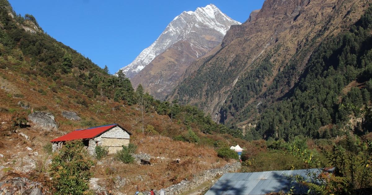
The walking conditions are physically demanding due to constant ups and downs. But the well-established paths keep your footing secure. Massive waterfalls crash down the stone cliffs right next to the trail to keep you cool during the humid afternoons. Also, you will pass your first restricted area checkpoint at Jagat, where park officials verify your mandatory guide documentation. This section serves as your vital physical warm-up. It prepares your legs for the thinner air that waits ahead in the Nubri Valley.
Middle Section: Namrung to Samagaon
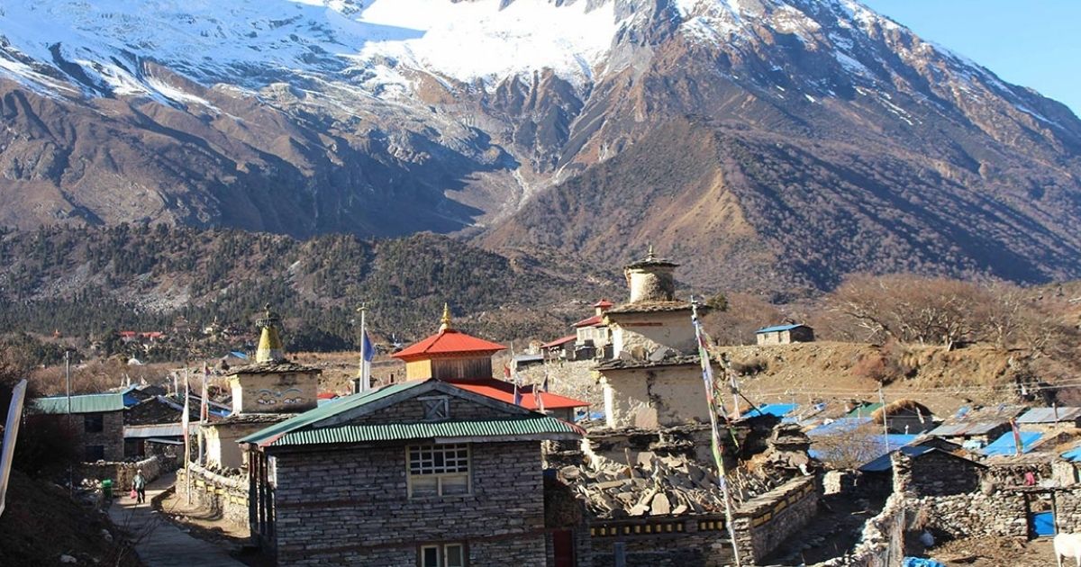
The valley opens wide as you enter the classic alpine zone. Tibetan Buddhist culture becomes dominant here: you will pass long Mani walls and white chortens decorated with prayer flags. The distance between Namrung and Samagaon is relatively short on paper. But your pace will naturally slow as the altitude rises above 3,500 m. You will catch your first clear views of Mt. Manaslu towering at 8,163 m. The local people wear traditional Tibetan wrap clothing. Likewise, the architecture shifts to stone flat-roofed houses clustered around ancient monasteries.
Upper Section: Samagaon to Larkya La Pass
This is the most famous part of your Himalayan journey. The high alpine terrain is completely barren and raw. You will walk past the frozen waters of Birendra Lake and cross massive lateral moraines. But the physical distances feel twice as long here. The severe lack of oxygen slows your feet down, and you can possibly get altitude sickness. Your body burns twice as much energy just to move forward on the loose scree and rocky paths.
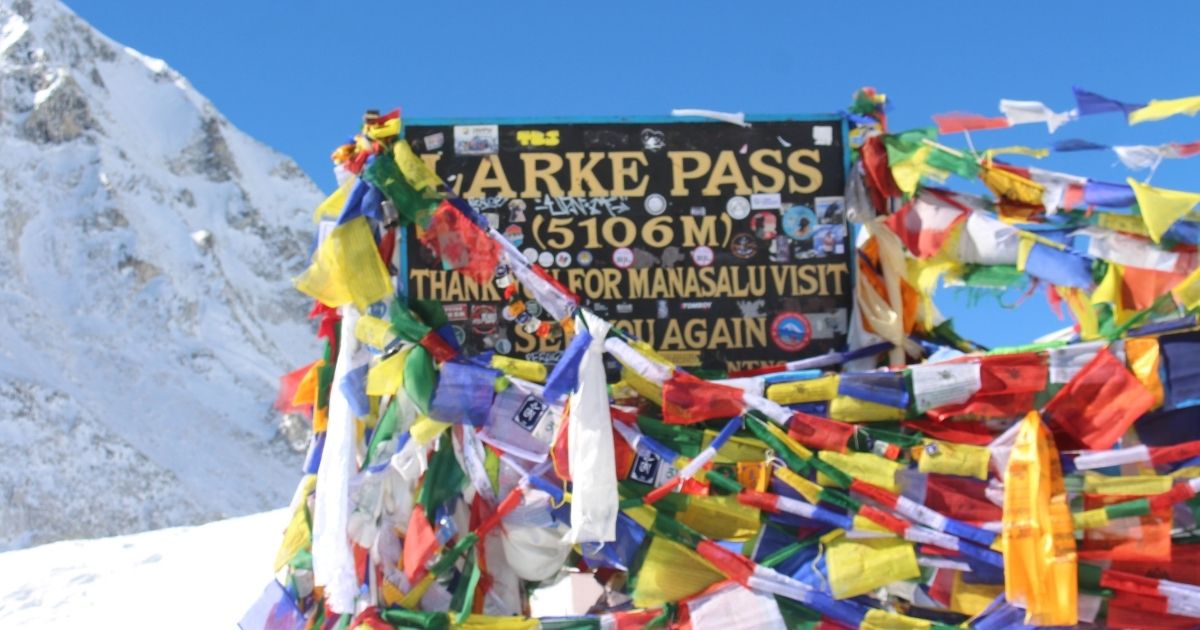
The ultimate test comes during the pre-dawn push to the summit of Larkya La Pass at 5,106 m. You must fight freezing temperatures that drop down to -10°C (14°F) in the dark. But the mental grit pays off when you reach the top. The prayer flags mark your victory against the high altitude. From the crest, a steep and slippery descent takes you down onto the lateral moraine toward Bimthang. This drops you safely back into the shelter of the pine forests.
The 2026 Manaslu Road Update: How Jeep Trails Are Changing the Start and End Distance
Road construction completely shifts the logistics of the Manaslu Circuit Trek in 2026. Dirt tracks now push deep into the Budhi Gandaki valley on the eastern side and climb past Dharapani on the western side. These rough paths allow local sharing jeeps and private four-wheel-drive vehicles to transport trekkers further into the valley. This change slices several days of low-altitude walking from the traditional route. You will no longer spend your first days walking past Soti Khola on dusty flats. But this infrastructure directly alters the wilderness atmosphere of the lower trails.
This vehicle access brings a clear mix of practical benefits and experiential losses. You can now bypass the hot, humid lower sections and start walking at higher, cooler elevations. This saves travelers with tight schedules valuable time. It also creates a safety net, as emergency vehicles can reach deeper into the valley during medical crises. But walking alongside active jeep tracks introduces noise and dust. The traditional slow immersion into local Gurung culture is disrupted as vehicles rush past ancient trading villages. Meanwhile, the rapid motorized ascent forces trekkers to monitor their early acclimatization much more strictly.
| Trek Version | Distance | Duration | Experience |
| Traditional Route | 177 km | 14 to 17 days | Slow cultural immersion through subtropical lowlands. Quiet trails follow the river, free of vehicular noise. |
| Road-Access Route | 110 km | 10 to 12 days | Fast-paced approach bypassing low-altitude valleys. Shorter walking days mixed with dusty, active jeep tracks. |
How Altitude Changes the Perception of Distance
Trekking distance alone does not determine the difficulty of the Manaslu Circuit Trek. You cannot plan your days based solely on distance traveled. At sea level, a 10 km walk on flat ground takes roughly two hours. But at high elevations, your body works twice as hard to cover that exact same distance. This happens because air pressure drops as you climb higher. The air molecules are spread out, so every breath you take contains fewer oxygen molecules. Your heart and lungs must pump faster just to keep your muscles functioning.
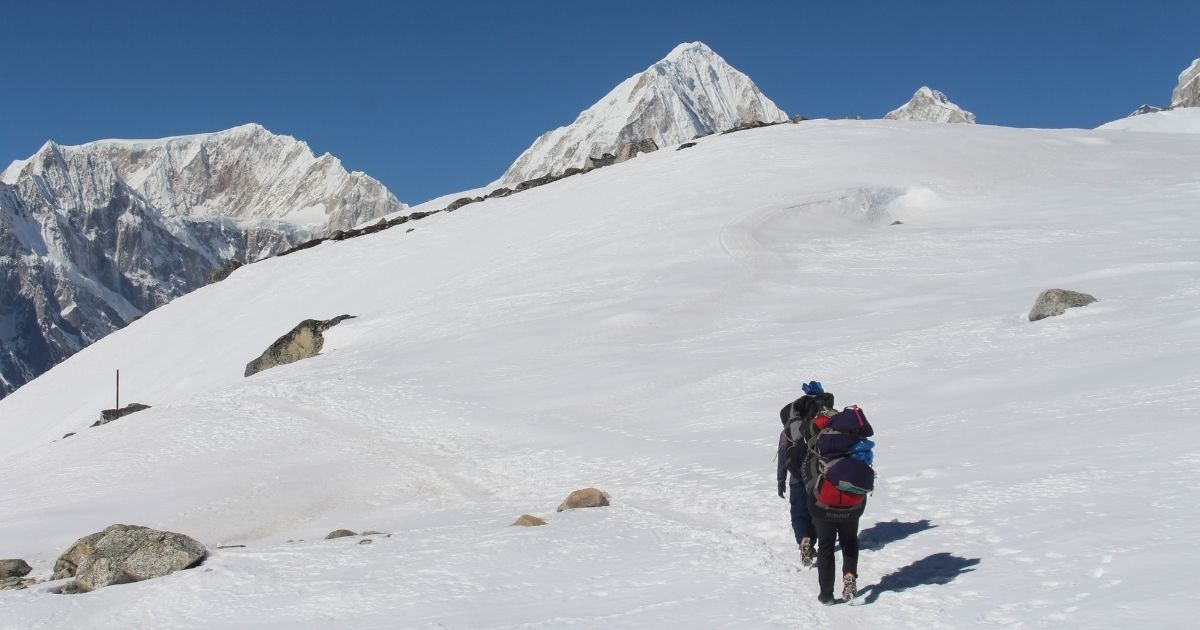
The oxygen reduction slows your pace and causes rapid fatigue. At 5,000 m, each breath gives you roughly half the oxygen you get at sea level. A 10 km day at this height requires heavy breathing, frequent rest stops, and a slow, rhythmic stride. Meanwhile, your body burns extra energy just to stay warm and process food in the thin air. You will feel exhausted after a distance that seems short on a map. For this reason, we measure our trekking days in hours rather than kilometers to ensure your safety and proper acclimatization.
Distance vs. Reality: Factors That Affect Your Daily Trekking Pace
The Manaslu Circuit Trek distance on a map and in reality is quite different. The maps show horizontal distances between teahouses. But a flat line on a map does not match the real physical cost of the Himalayan terrain. Your daily pace depends on underfoot reality, not paper metrics. A 15 km day can feel like a marathon when the trail forces you over loose rocks, slippery shale, and steep stone staircases.
The weather can also shift your timeline in an instant. Monsoon rain creates deep mud in the lower valleys, which slows your boots. Meanwhile, autumn snow blocks upper segments and requires slow, deliberate tracking. Your pack weight, physical conditioning, and the frequency of mule trains also dictate how many kilometers you cover each hour.
Want a More Comfortable Trekking Pace?
If the daily distance feels challenging, customize your Manaslu Circuit itinerary with a pace and schedule that give you more time to walk, rest, and acclimatize.
The Budhi Gandaki Gorge Effect
The lower sections of the route hug the deep, narrow walls of the Budhi Gandaki River. Here, the trail never stays level. You will constantly drop down to the rocky riverbank and then climb hundreds of vertical meters to bypass sheer cliffs. These relentless switchbacks mean your GPS might show little horizontal progress, while your legs experience significant cumulative elevation changes. Suspension bridges create bottleneck points, where you must wait for yak caravans to cross before you can proceed.
Altitude and Decreasing Oxygen Levels
As you move past the treeline into the upper alpine zones, the thin air alters your speed entirely. At Namrung, the elevation reaches 2,630 m, and it continues to climb to the Larkya La Pass at 5,106 m. Decreasing barometric pressure means there are fewer oxygen molecules per breath. Your muscles receive less fuel, which forces you to take shorter steps and to take more frequent rest breaks. A distance that took two hours at sea level will easily take four hours above 4,000 m.
Physical Preparation: How to Train for 15+ Kilometers a Day
You cannot build Himalayan stamina on flat treadmills alone. To prepare for the long daily stages, start your training at least twelve weeks before you fly to Kathmandu. Focus on weighted stair climbing and uphill hiking to build your quad and calf strength. Load a backpack with five kilograms of weight and find steep hills or stadium stairs. Work your way up until you can complete a four-hour hike without joint pain.
Cardiovascular fitness determines how well your body processes limited oxygen. Mix two long, slow weekend hikes with mid-week high-intensity interval training. Swimming, cycling, and rowing strengthen your heart and lungs without stressing your knees. Likewise, add core exercises like planks and squats to your routine. A strong core stabilizes your balance when you walk across uneven boulder fields with a heavy pack.
Common Mistakes Trekkers Make When Judging Trek Distance
- Confusing flat maps with trail reality: Trekkers look at a 12 km distance on a paper map and expect a flat city walk. They forget to calculate the vertical zigzag patterns that add hours to the journey.
- Ignoring the weight of the daypack: Walking fifteen kilometers unburdened feels simple. But carrying a six-kilogram pack changes your center of gravity, tires your shoulders, and slows your pace by several minutes per kilometer.
- Failing to factor in livestock traffic: Heavy mule trains and yak caravans have the right of way on narrow cliff trails. Waiting for these animals to pass at suspension bridges and cliff edges drains your time.
- Counting kilometers instead of hours: In the high mountains, altitude slows your movement. A five-kilometer stretch below the treeline takes an hour, but the same distance above 4,000 m takes three hours.
- Assuming consistent underfoot conditions: Flat maps do not show loose scree, wet stone steps, or muddy landslide bypasses. Slippery terrain forces you to take shorter, slower steps to prevent ankle injuries.
Distance Comparison: Manaslu Circuit vs Other Popular Treks
Every trail in Nepal has a distinct physical demand, determined by terrain, walking days, and maximum altitude. We compare the Manaslu Circuit with four other legendary routes below to help you evaluate the total walking distance, standard timeline, and overall physical grading.
| Trek | Distance | Duration | Difficulty |
| Manaslu Circuit Trek | 177 km | 14 days | Strenuous |
| Everest Base Camp Trek | 130 km | 12 days | Strenuous |
| Annapurna Base Camp Trek | 115 km | 10 days | Moderate |
| Annapurna Circuit Trek | 160 km | 14 days | Strenuous |
| Langtang Valley Trek | 77 km | 8 days | Moderate |
Have Questions About Your Trek?
Get quick answers about routes, costs, permits, difficulty, or travel dates from our trekking team before you book.
Conclusion
The Manaslu Circuit Trek covers approximately 177 kilometers (110 miles) and takes trekkers through a demanding, high-altitude loop around the eighth-highest mountain in the world. Modern road construction in 2026 has introduced vehicle access to the lower valleys, allowing shorter itineraries and reducing foot mileage to around 110 kilometers by using local jeeps. But this mechanical shortcut does not diminish the physical reality of the journey. The trail forces you to transition rapidly from low subtropical gorges up to the alpine heights of the Larkya La Pass at 5,106 m.
Download the itinerary and enjoy the best Manaslu Circuit trek in 2026.

.webp)

.webp)
.webp)