Quick Facts at a Glance
| Feature | Details |
| Trek region | Langtang National Park, Rasuwa District, north of Kathmandu |
| Starting point | Syabrubesi (1,503 m) |
| Highest point | Tserko Ri (5,033 m) (optional), Kyanjin Ri (4,773 m) |
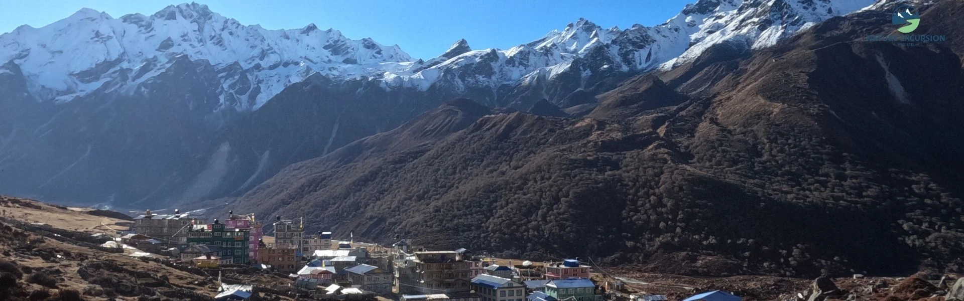
| Highest overnight stay | Kyanjin Gompa (3,870 m) |
| Standard route | Syabrubesi → Lama Hotel → Ghodatabela → Langtang Village → Mundu → Kyanjin Gompa → Kyanjin Ri/Tserko Ri → back via the same trail |
| Trek duration | 7-10 trekking days, including side hikes |
| Total walking distance | 65-75 km round trip, excluding longer side trips |
| Daily walking hours | 4-6 hours |
| Difficulty | Moderate |
| Accommodation | Teahouse |
| Best time | March - May and September - November |
| Major side trips | Kyanjin Ri, Tserko Ri, Langshisha Kharka, Yala Peak Base Camp |
| Required permits | Langtang National Park Entry Permit and TIMS (depending on current regulations and operator requirements) |
Plan Your Langtang Trek
Ready to follow the map and start trekking? Talk to our team for route advice, trek details, availability, and help planning your Langtang adventure.
Why Understanding the Langtang Valley Trek Map Makes Your Journey Easier
The Langtang Trek map makes your journey easier by showing the entire route. It’s completely different from city maps. It’s a Himalayan trekking map that highlights elevation gain, river crossings, forests, villages, suspension bridges, glaciers, and ridgelines. These details are often more useful than knowing the distance alone.
Furthermore, a trek map helps you plan your daily walk and understand what to expect along the Langtang region trail. You can identify steep sections, nearby villages, and important landmarks throughout the trek. Also, offline maps are especially helpful when trekking in the mountains, where weather conditions can change quickly. Clouds frequently cover the upper valley, especially in the late afternoon. Having an offline map downloaded beforehand gives you confidence if visibility suddenly drops.
Likewise, for photographers and nature lovers, a trekking map can help you find popular viewpoints, glacier views, and places to enjoy sunrise and mountain panoramas. Some of the best viewpoints are located just a short distance from the main trail and are easy to find with a good map.
What Is the Standard Route for the Langtang Valley Trek Map?
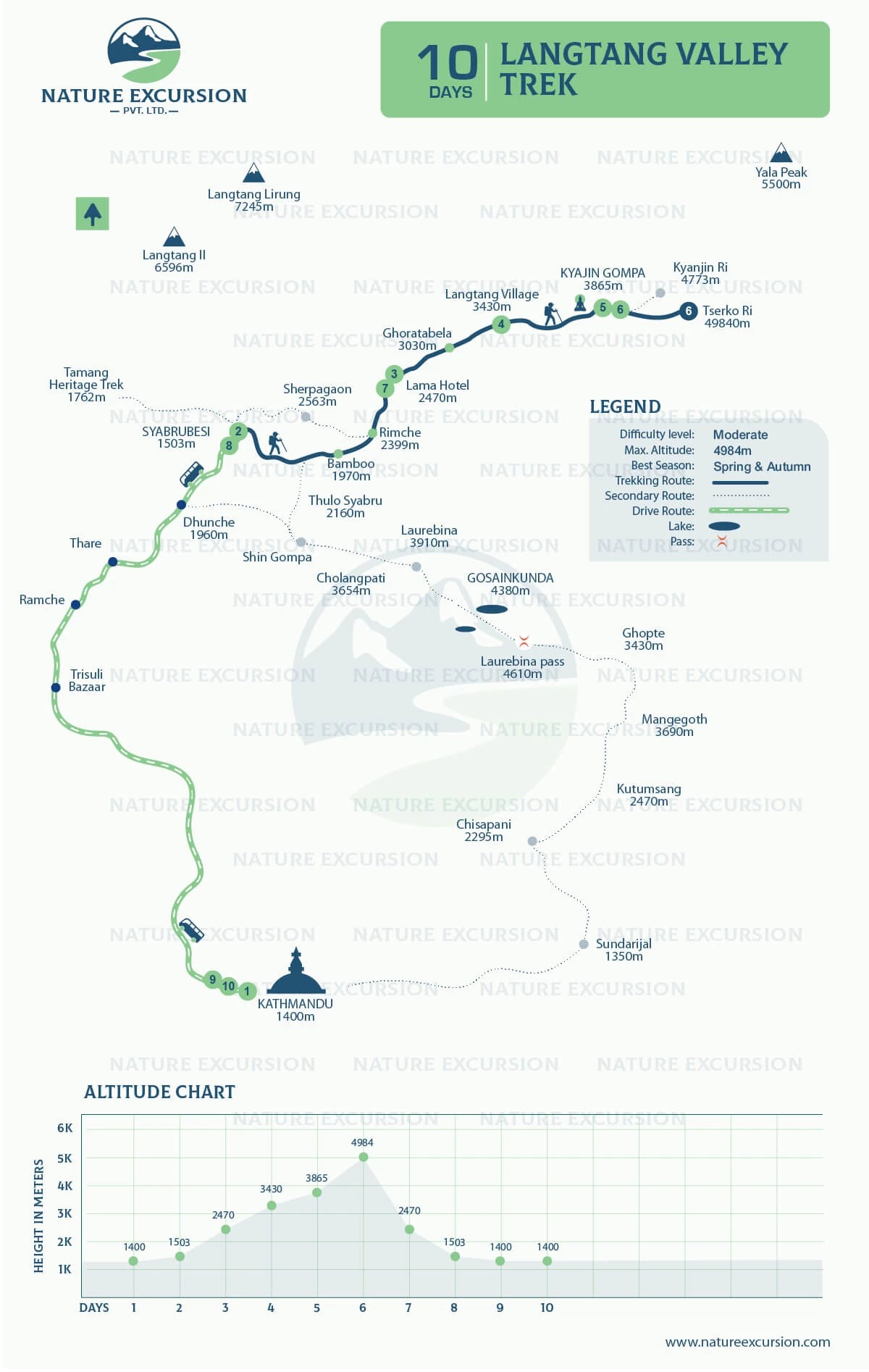
The standard Langtang trek route on most maps is a straight, in‑and‑out trail from Syabrubesi, Lama Hotel, Ghodatabela, Langtang Village to Kyanjin Gompa, then back the same way.Some trekking maps may include alternative routes through villages such as Sherpagaon or Thulo Syabru. But the trekking line always funnels into Lama Hotel, then follows the river and the valley floor up to Langtang Village and Kyanjin Gompa.
It also includes optional side hikes to Kyanjin Ri and Tserko Ri. Most itineraries take 7 to 10 days, including an acclimatization day at Kyanjin Gompa.
On the map, the core route looks like this:
- Day 1: Drive from Kathmandu to Syabrubesi.
- Day 2: Trek from Syabrubesi to Lama Hotel.
- Day 3: Trek from Lama Hotel to Langtang Village.
- Day 4: Trek from Langtang Village to Kyanjin Gompa.
- Day 5: Optional hike to Kyanjin Ri or Tserko Ri and overnight stay at Kyanjin Gompa.
- Day 6: Trek from Kyanjin Gompa to Lama Hotel.
- Day 7: Trek from Lama Hotel to Syabrubesi.
- Day 8: Drive back to Kathmandu or stay an extra night if preferred.
Day-by-Day Langtang Valley Trek Route
A map becomes truly useful when you combine the line on the screen with distance, elevation, and time. Below is a practical, day-by-day Langtang trek route from Syabrubesi to Kyanjin Gompa and back:
Day | Route | Distance | Duration | Elevation (Start → End) | Difficulty | Accommodation | Highlights |
1 | Kathmandu – Syabrubesi (Drive) | 122 km | 7-9 hours drive | 1,400 m → 1,503 m | Easy | Teahouse | Trishuli River, mountain road |
2 | Syabrubesi – Lama Hotel | 13 km | 6-7 hrs walk | 1,503 m → 2,470 m | Moderate | Teahouse | Suspension bridges, bamboo forests |
3 | Lama Hotel – Langtang Village | 14 km | 6-7 hrs walk | 2,470 m → 3,430 m | Moderate | Teahouse | Ghodatabela, Langtang Lirung views |
4 | Langtang Village – Kyanjin Gompa | 6 km | 3-4 hrs walk | 3,430 m → 3,870 m | Moderate | Teahouse | Mani walls, yak pastures, monastery |
5 | Explore Kyanjin Ri or Tserko Ri | 6-14 km | 4-8 hrs walk | Up to 4,984 m | Challenging | Teahouse | 360° Himalayan panorama from ridges |
6 | Kyanjin Gompa – Lama Hotel | 18 km | 8-9 hrs walk | 3,870 m → 2,470 m | Moderate | Teahouse | Wide valley views, forest descent |
7 | Lama Hotel – Syabrubesi | 13 km | 6-7 hrs walk | 2,470 m → 1,503 m | Easy | Teahouse | Dense forests trail, final day through rhododendron and bamboo forest |
8 | Syabrubesi – Kathmandu (Drive) | 122 km | 7-9 hrs drive | 1,503 m → 1,400 m | Easy | Hotel | Return to Kathmandu |
Note: Distances and times vary a bit between agencies and maps, but this table reflects what most current 2025/2026 Langtang maps and trekking companies show.
How the 2015 Earthquake Changed the Langtang Trek Trail
The devastating earthquake of April 2015 forever changed the history of Langtang Valley. A massive avalanche and landslide from Langtang Lirung buried the original Langtang Village and caused significant loss of life.

Today's trek in the Langtang region remains emotional for many visitors, but it also tells a story of resilience. After the disaster, the local community rebuilt Langtang Village on safer ground nearby. Now, the village has new teahouses, lodges, schools, and community buildings. Memorials along the trail also honor those who lost their lives during the earthquake.
The trail itself has also improved significantly. Damaged bridges have been replaced, landslide-prone areas have been stabilized, and some sections of the trail have been rerouted for safety. The map of the Langtang Valley trek also shows the updated route, including new bridges and the rebuilt Langtang Village.
Plan an Langtang Trip That Fits You
Want more flexibility? Adjust your Langtang itinerary, trekking days, stops, and activities to match your travel preferences.
What Does the Langtang Valley Trek Map Show?
A detailed Langtang Valley Trek map shows the main trekking route, side trails, elevations, terrain, overnight stops, daily walking hours, villages along the way, and key services such as teahouses and health posts. It combines topography, contour lines, landmarks, rivers, villages, and side trails. When used alongside an offline GPS app, they become an excellent planning and navigation tool.
Here's what you should expect to find on a good Langtang trekking map.
Map feature | Its importance |
Trek route | Shows the standard trail from Syabrubesi to Kyanjin Gompa and return. |
Villages | Helps you plan overnight stops, lunch breaks, and acclimatization. |
Elevation | Indicates altitude gain, plan acclimatization, and decide where to add a rest day. |
Rivers | Langtang Khola, Bhote Koshi, and tributaries, useful for water planning and understanding the valley shape. |
Suspension bridges | Critical crossings where the trail changes sides of the valley, often marked with bridge symbols. |
Teahouses | Shows accommodation options throughout the trek. |
Side trips | Marked routes to Kyanjin Ri, Tserko Ri, Langshisha Kharka, Yala Base side areas, and Gosainkunda extension. |
Viewpoints | Marks the best sunrise and mountain photography locations. |
Forest & terrain zones | Shifts from subtropical forest to alpine meadow and rocky moraine, so you know when trail conditions change. |
Monasteries & cultural sites | Includes Kyanjin Gompa and other landmarks. |
National Park boundary | Shows the protected area of Langtang National Park. |
Getting the Langtang Valley Trek Map
It’s easier to find a reliable map of the Langtang trek as they are available in many places. You can carry both a printed map and an offline digital map and use each for different purposes (we will discuss these map types in detail in the next section). If you're booking your Langtang Valley Trek package through Nature Excursion, you'll also receive detailed route information before departure.
Physical Printed Maps
Despite smartphones becoming increasingly reliable, a printed trekking map still has advantages. It provides a wider perspective of the valley. It shows the relationship between villages, mountains, glaciers, and rivers. You can also mark daily progress, note viewpoints, or discuss route options with your guide.
Printed topographic maps of Langtang National Park are available in Thamel in Kathmandu, especially around Tridevi Marg. They usually use scales around 1:100,000–1:125,000 and show contour lines, peaks, passes, and villages. Printed maps usually cost between NPR 500 and NPR 800. Waterproof laminated versions are also available for around NPR 1,200.
Before purchasing, make sure to check the edition date. Maps printed before 2016 may show the old Langtang Village route from before the 2015 earthquake. If you want more detailed trail information, you can also buy the 1:50,000 scale map, although it covers a smaller area.
Some popular publishers of physical printed trek maps include:
- Himalayan MapHouse: One of Nepal's most popular trekking map publishers. It’s known for detailed, waterproof topographic maps of major trekking regions, such as the Everest Base Camp, the Annapurna Circuit, and others.
- Nepa Maps: Offers easy-to-read maps with clear trail information and useful legends for both popular and less-visited trekking routes. Scale range is 1:125,000.
- TAAN Maps:Published by the Trekking Agencies' Association of Nepal, these maps are regularly updated and provide detailed information about trekking routes.
- Vajra Publications: Produces trekking maps that include cultural and heritage information alongside trail details.
- Himalaya Kartographisches Institut: Known for clean and simple maps that are ideal for trekkers following the main tea house routes.
Digital and Offline GPS Map Apps
Digital maps show your real-time GPS location on the trekking trail. Likewise, offline GPS maps (such as Organic Maps, Gaia GPS, Maps.me, trekGuard GPX, and AllTrails) have become much more reliable over the last few years.
Since mobile coverage becomes limited above Lama Hotel, downloading maps before leaving Kathmandu is essential. Once the maps are downloaded, you can use them without an internet connection or mobile data. They help you navigate the trail, especially during poor weather or low visibility.
The following apps are popular among trekkers:
App | Offline Maps | GPX Support | Ease of Use | Recommended |
Organic Maps | Yes | Limited | Excellent | ⭐⭐⭐⭐⭐ |
Gaia GPS | Yes | Yes | Excellent | ⭐⭐⭐⭐⭐ |
Maps.me | Yes | Basic | Very easy | ⭐⭐⭐⭐ |
TrekGuard GPX | Yes | Yes | Advanced | ⭐⭐⭐⭐ |
AllTrails | Partial | Yes | Good | ⭐⭐⭐ |
- Organic Maps (iOS and Android): Organic Maps is one of the best free options for trekkers. It is easy to use, lightweight, and shows trekking trails and teahouse locations. While it does not provide elevation profiles, it is more than sufficient for navigating the main Langtang Valley route.
- Gaia GPS iOS and Android): Gaia GPS offers detailed topographic maps with elevation contours, making it useful for planning side hikes such as Tserko Ri. It supports GPX files and works completely offline once the Nepal map has been downloaded. A paid subscription is required.
- AllTrails (iOS and Android):AllTrails is useful for reading trail reviews and checking recent trekking conditions. Offline maps are available with the paid version. When downloading GPX tracks, make sure they are updated after 2016 to reflect the current Langtang trekking route.
- TrekGuard (iOS and Android):Designed specifically for trekking in Nepal, it offers a free Langtang Valley GPX track. It includes altitude-monitoring features that help trekkers track their ascent. It is particularly useful for solo trekkers and those who want additional safety features.
How to Get and Use a Langtang Trek GPX File
A GPX file (GPS Exchange Format) is a digital route file that stores waypoints and trekking trails. You can load it into GPS apps like Gaia GPS, Organic Maps, or Maps.me, or devices to help navigate the Langtang Valley Trek. You can also mark important stops along the route, including Lama Hotel, Langtang Village, and Kyanjin Gompa.
A GPX file is helpful for navigation, especially when visibility is poor or if you want to track your progress. However, it should not replace local advice or trail signs. Routes may change due to landslides, bridge repairs, or seasonal conditions.
Follow these steps to use a GPX file:
- Download a Langtang Valley GPX file to your computer or phone from a reliable source before arriving in the trekking region.
- Import the GPX file into your preferred offline map app, such as Gaia GPS or Organic Maps, using the "Import" or "Open File" option.
- If you use a Garmin GPS device (such as the GPS 64 or inReach), connect it to your computer using a USB cable and copy the GPX file into the Garmin/GPX folder.
Note:Before using any GPX file, make sure it has been updated after 2016. Older GPX tracks may follow the route that existed before the 2015 earthquake and could show outdated trail information. It is also a good idea to compare the GPX route with the latest printed trekking maps, especially for the section between Langtang Village and Kyanjin Gompa.
GPS Coordinates of Key Waypoints (Approximate)
The following coordinates are suitable for planning purposes. Exact coordinates vary slightly between maps, but most current trek resources place the main locations roughly as follows.
Location | Approximate Coordinates | Elevation |
Kathmandu | 27.7172° N, 85.3240° E | 1,400 m |
Syabrubesi | 28.167° N, 85.307° E | 1,503 m |
Bamboo | 28.193° N, 85.385° E | 1,970 m |
Lama Hotel | 28.211° N, 85.426° E | 2,470 m |
Ghodatabela | 28.238° N, 85.503° E | 3,030 m |
Langtang Village | 28.211° N, 85.565° E | 3,430 m |
Kyanjin Gompa | 28.213° N, 85.614° E | 3,870 m |
Kyanjin Ri | 28.223° N, 85.620° E | 4,773 m |
Tserko Ri | 28.238° N, 85.638° E | 5,033 m |
Permits and Trail Entry Points: What the Map Shows
Along the Langtang Valley trek route, you'll pass permit checkpoints where officials verify your trekking documents. The Langtang Valley trek map usually highlights permit checkpoints near Dhunche or the park gate and sometimes marks army posts and village check‑ins along the route. Likewise, the trail entry point is Syabrubesi.
That said, the permits required to trek to Langtang Valley are:
Permit | Purpose | Where to obtain | Approximate cost |
Langtang National Park Entry Permit | Conservation and park access | Nepal Tourism Board, Kathmandu, or the entry checkpoint | NPR 3,000 per person (foreign nationals) |
TIMS Card | Trekker registration, safety tracking for organized groups | Registered trekking agencies or the relevant authority | Varies |
As of 2026, the TIMS card is no longer enforced or mandatory to obtain. Permit requirements occasionally change. If you're joining one of our Langtang Valley Trek departures, Nature Excursion arranges all necessary permits before the trek begins.
When is the Best Time to Trek Langtang Valley
In the Langtang region, the landscape changes throughout the year, so the trail will feel completely different depending on the season. But the way the route looks on the Langtang Valley trek map doesn’t change as much as the way it feels underfoot:

Spring and autumn are the most reliable times for the Langtang trek, offering clear mountain views and comfortable walking conditions. Spring transforms the forests into a sea of blooming rhododendrons, while autumn offers cool air and exceptional visibility. Winter brings quieter trails and beautiful snow-covered scenery, but mornings can be extremely cold, and higher viewpoints like Tserko Ri may become more challenging after fresh snowfall.
Now, let’s look at how conditions change throughout the year:
Season | Visibility | Trail condition | Temperature | Recommendation |
Spring (Mar - May) | Excellent | Dry, stable, occasional late snow at higher points | Mild days, cold nights at Kyanjin | Best overall: flowers, views, comfortable walking |
Summer/Monsoon (Jun - Aug) | Limited | Mud, leeches, landslide risk, slippery bridges | Warm, humid lower down; cooler higher | Not ideal; only for experienced trekkers with flexible plans |
Autumn (Sep - Nov) | Outstanding | Firm trails, low rain, early snow possible at viewpoints | Cool days, chilly nights | Best overall |
Winter (Dec - Feb) | Very good | Snow in the upper valley, icy sections near Kyanjin, and viewpoints | Cold to very cold, sub‑zero nights | Good if well‑equipped; trails quieter but more serious |
Is the Langtang Valley Trek Route Safe for Beginners?
Yes, the Langtang Valley Trek route is safe for beginners. It’s one of the best Himalayan treks for beginners. The route is well-established, well-marked, and easy to follow, which is why it is often recommended as a first trekking experience in Nepal.
Also, the Langtang trail has very few confusing junctions. It mainly follows the Langtang Khola (river) through several villages before reaching Kyanjin Gompa. However, easy navigation does not mean the trek is easy. You will be walking at high altitude for 4 to 6 hours a day on uneven mountain trails. Good preparation and fitness are important for completing the trek comfortably. Also, you need to look out for the signs of altitude sickness.
That said, the Langtang Valley Trek is suitable for you if you:
- Can hike for 4 to 6 hours a day on uneven terrain.
- Have a good level of fitness.
- Prepare for the trek at least four weeks in advance.
- Are mentally prepared for several days of walking in the mountains.
- Can maintain a steady walking pace throughout the trek.
When Is the Best Time for Langtang?
Not sure when to follow the Langtang route? Check the best seasons, weather, trail conditions, and mountain views before planning your trek.
Trail Markers, Teahouses, and Navigation on the Ground
The Langtang Valley Trek is one of the easier Himalayan treks to navigate. Along the route, there are painted trail markers and signboards below 3,500 m, stone cairns (small rock piles used as trail markers) at higher elevations, suspension bridges connecting different sections of the trail, teahouses every few hours where you can rest or have a meal, and local residents, guides, and yak herders who can help with directions if needed. This makes navigating the ground easier.
Similarly, above 4,200 m, including the summit trails to Kyanjin Ri and Tserko Ri, there are no official trail markers. Carrying an offline GPS map or GPX file is highly recommended if you plan to hike these viewpoints. The Kyanjin Cheese Factory at Kyanjin Gompa is another useful landmark and a popular stop for trekkers. You can also try locally made yak cheese, which makes a good energy snack for longer hiking days.
There are two main suspension bridges along the trek, one just after Bamboo and another before Rimche. Both are sturdy but narrow, so trekkers cross them one at a time. After Lama Hotel, the trail remains on the north side of the river, and no additional river crossings are required. Mobile network coverage is available in Syabrubesi and can be intermittent at Lama Hotel on NTC and Ncell networks. Above Lama Hotel, there is usually no reliable mobile signal, although you may occasionally get limited NTC coverage at Kyanjin Gompa.
Extend Your Adventure Beyond Langtang Valley
If you have extra time, there are several trekking routes that can be combined with the Langtang Valley Trek. These extensions offer a mix of mountain scenery, sacred lakes, and cultural experiences.
Langtang-Gosaikunda-Helambu Trek Extension
Langtang Gosaikunda Helmabu extends your Langtang Valley Trek by 4 to 5 days. From Kyanjin Gompa, the trail continues to the sacred Gosaikunda Lake (4,380 m) via Lauribina Pass (4,610 m). From there, you continue toward Helambu. This route combines mountain scenery, high-altitude lakes, and cultural experiences, and is offered as the 15-day Langtang Gosaikunda Helambu Trek by Nature Excursion.
Gosaikunda Lake as a standalone trek
If your main goal is to visit Gosaikunda Lake, you can do it as a standalone trek. The route usually starts from Dhunche and takes around 8 days. It is a good option for trekkers who want to experience the sacred alpine lakes without trekking all the way to Kyanjin Gompa.
Tamang Heritage Trek
The Tamang Heritage Trail is ideal for trekkers who are more interested in culture and local life. It follows a lower-altitude route through traditional Tamang villages and can be combined with the Langtang Valley Trek or done separately. Some of the highlights include traditional Tamang villages and local homestays, natural hot springs at Tatopani, ancient monasteries and cultural sites, and Nagthali Hill (3,300 m), a popular viewpoint along the trail.
Essential Tips Before Following the Langtang Valley Trek Map
A good trekking route map of Langtang is helpful, but proper preparation is just as important. Follow these practical tips in mind before starting the Langtang Valley Trek.
- Download offline maps before leaving Kathmandu, as mobile network coverage is limited in the upper parts of the trail.
- Carry both a printed trekking map and an offline GPS app. They work well as backups for each other.
- Start your trek early each morning. The weather is usually clearer in the morning, and you'll have enough time to reach your destination comfortably.
- Pay attention to altitude gain. Although some sections look short on the map, the climb can be physically demanding.
- Walk at a steady pace and stay well hydrated.
- Use the elevation profile on your map to plan acclimatization and avoid gaining altitude too quickly.
- Keep a power bank with you. Most teahouses offer charging facilities for an additional fee, especially at higher elevations.
- Carry enough Nepalese Rupees for accommodation, meals, snacks, charging devices, Wi-Fi, and hot showers. There are no ATMs along the trekking route.
- Pack clothing for changing weather conditions. Days can be warm, while mornings and evenings at higher elevations are often cold.
- Check the latest permit requirements and park regulations before starting your trek.
- During the monsoon and winter seasons, pay extra attention to trail conditions, including landslide-prone areas, snow-covered sections, and river crossings.
- Respect local customs by walking clockwise around prayer wheels, mani walls, and other Buddhist monuments.
- Always ask permission before taking photographs of local people.
- Help protect Langtang National Park by carrying a reusable water bottle and disposing of your waste responsibly.
- Allow some flexibility in your itinerary. Weather, road conditions, and altitude may require minor changes to your trekking plans.
- If you are trekking with a guide, review the next day's route together each evening. It is an easy way to understand the terrain and prepare for the journey ahead.
Have Questions About Your Trek?
Get quick answers about routes, costs, permits, difficulty, or travel dates from our trekking team before you book.
Conclusion
This way, a detailed Langtang Valley Trek map is one of the best tools for planning your trek. It helps you understand the route from Syabrubesi to Kyanjin Gompa, daily walking distances, altitude changes, optional side hikes, and possible trek extensions.
When used together with updated trail information, offline GPS maps, and local guidance, it makes the trek easier to plan and navigate. Also, good preparation is equally important. With good preparation, you can enjoy a safe journey through one of Nepal's most beautiful and beginner-friendly Himalayan trekking regions.
Planning your Langtang Valley Trek? Contact us for expert advice, permit assistance, and a well-organized trekking experience. Our local team is ready to help you plan your adventure.
Things Trekkers Often Ask
How Do I Get to the Langtang Trek Starting Point?
The common way to get to the Langtang trek starting point is by driving from Kathmandu to Syabrubesi. The drive takes 7 to 9 hours, depending on road and weather conditions.
Can You Start the Langtang Trek from Dhunche?
Yes, you can start the trek from Dhunche. This option is popular among trekkers who combine the Langtang Valley with the Gosaikunda Trek or the Tamang Heritage Trail. However, Syabrubesi remains the standard starting point for the classic Langtang Valley Trek.
Where Can You Stay During the Langtang Valley Trek?
Accommodation is available throughout the Langtang Valley Trek. Most overnight stops have family-run teahouses that offer simple private rooms, shared bathrooms, and freshly prepared meals. Common places to stay include Syabrubesi, Lama Hotel, Langtang Village, and Kyanjin Gompa.
Is Google Maps reliable for the Langtang Trek?
No, Google Maps is not recommended for trekking in Langtang Valley. It’s because it does not accurately show trekking trails, side hikes, or elevation changes. Also, mobile data is unreliable after Syabrubesi. It’s a good idea to rely on offline apps such as Organic Maps or Gaia GPS.
Are There Dangerous Sections on the Route?
The Langtang Valley Trek is generally safe, but some sections require extra caution. Trails between Syabrubesi and Lama Hotel can be slippery after rain. Winter snow may affect parts of the trail near Ghodatabela, while the climbs to Kyanjin Ri and Tserko Ri are steep and rocky. During the monsoon season, temporary landslides may occur.
Which Is Harder: Tserko Ri or Kyanjin Ri?
Tserko Ri is more challenging than Kyanjin Ri. It is higher in altitude, involves a longer hike, and requires more physical effort. Kyanjin Ri is shorter and is often preferred by trekkers looking for a less demanding side hike.
Should I Trek Independently or Hire a Guide?
Both options are possible. Independent trekking offers more flexibility, while hiring a licensed guide provides additional support with navigation, pacing, and local knowledge. Guides can also help make your trekking experience safer and more enjoyable.
Is There a Map That Shows Both Langtang Valley and Gosaikunda Trails?
Yes, many trekking maps of Langtang National Park include the Langtang Valley Trek, Gosaikunda Trek, Tamang Heritage Trail, and sometimes the Helambu region. These maps are useful if you plan to extend your trek beyond Langtang Valley.
What Are the Best Offline Maps for the Langtang Valley Trek?
Organic Maps and Gaia GPS are two of the best offline map apps for the Langtang Valley Trek. Organic Maps is free and easy to use, while Gaia GPS offers more advanced features such as GPX route tracking and detailed topographic maps.