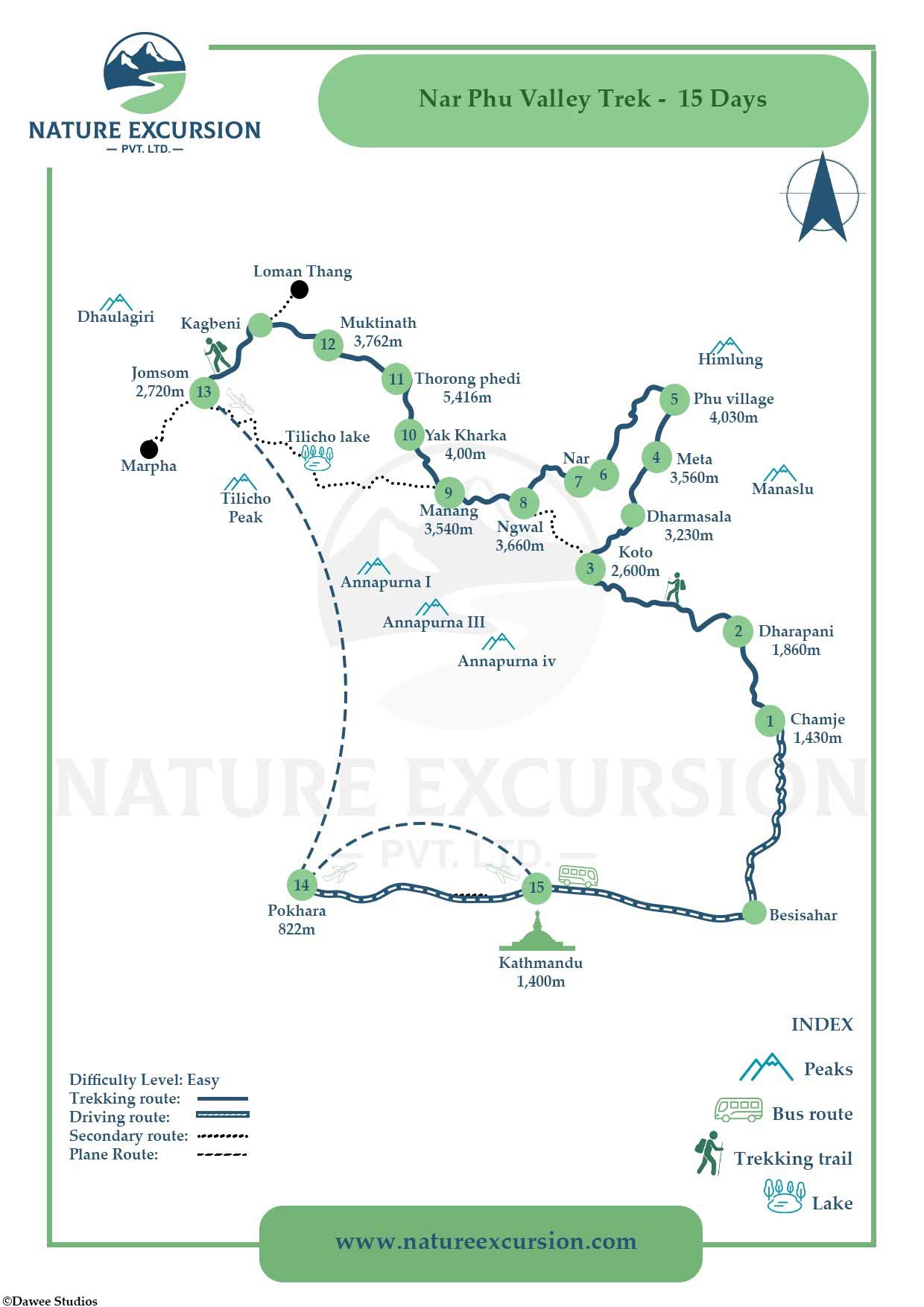
Have you ever wanted to explore one of Nepal's most remote and culturally preserved trekking regions? The Nar Phu Valley Trek Map helps trekkers visualize how this hidden valley connects directly to the Annapurna Circuit's busy trails. You can download offline map-tracking apps like Maps.me or Gaia GPS to your phone. For a physical option, high-resolution topographic maps can be purchased in Thamel, Kathmandu, while reliable digital route maps are available through verified local agencies.
You must save the Annapurna region data while you still have internet access in Kathmandu or Besisahar. These mobile applications use your phone's built-in GPS sensor to pinpoint your location on the trail without using cellular data. The route branches off from Koto and deepens into a high-altitude wilderness before crossing the high Kang La Pass at 5,320 m to rejoin the main circuit at Ngwal. Despite its remote and rugged reputation, the trail layout remains straightforward when properly planned and mapped.
A major policy change by the Nepal Department of Immigration recently officially updated the group-size requirements. You can now legally obtain a Restricted Area Permit as a solo trekker. Please note that in addition to this Restricted Area Permit (which costs USD 100 per week in peak season), you must also obtain an Annapurna Conservation Area Project (ACAP) permit. You no longer need a second trekking partner, but a licensed local guide remains mandatory throughout the journey. The well-planned and mapped Nar Phu Valley Trek itinerary will ensure you have an amazing adventure in the mountains.
Quick Facts
Fact
Specification
Trip Duration
9 - 15 Days
Maximum Altitude
5,416 m (Thorong La Pass)
Second High Pass
5,320 m (Kang La Pass)
Difficulty Level
Strenuous
Group Size
1 to 16 pax
Mandatory Staff
Licensed local guide
Best Season
Spring (March to May) and Autumn (September to November)
Core Accommodation
Teahouse and Lodge
Package price
USD 1,572
Deposit required
USD 200
Need Help Understanding the Nar Phu Trek Map?
Have questions about daily distances, altitude gain, overnight stops, Kang La Pass, or route conditions? Talk to our team for practical route advice and help planning your trek.
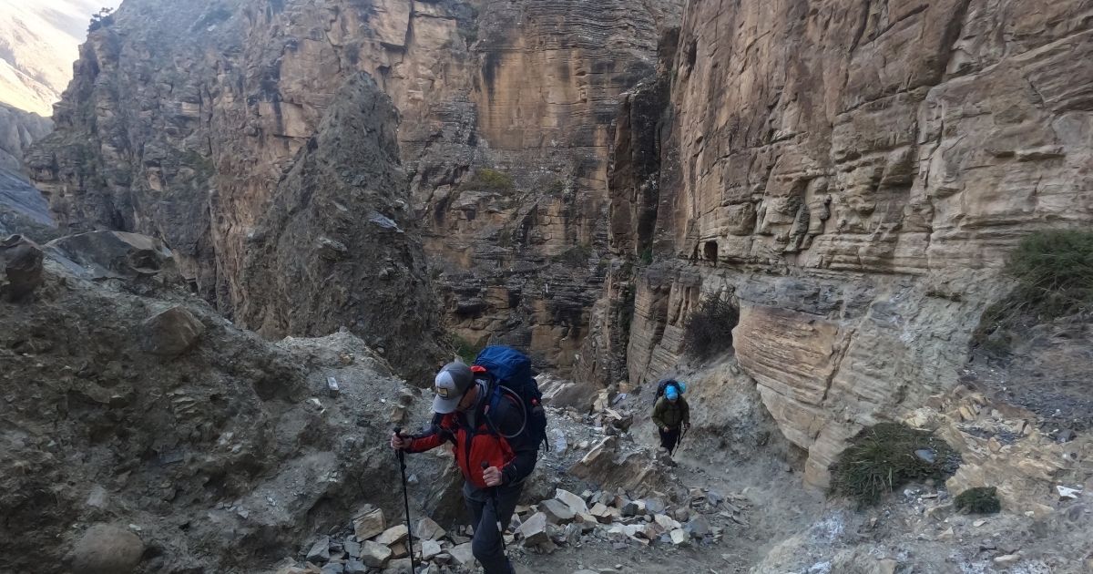
Nar Phu Valley is located in the remote Manang District of north-central Nepal, tucked away within the rugged Gandaki Province near the Tibetan border. This hidden valley is situated in the majestic Damodar Himal range, positioned just north of the popular Annapurna Circuit trekking route. The valley splits into two main areas: the ancient village of Nar to the south and Phu to the north. Despite its extreme remoteness, you can access this wild landscape by branching off the main circuit route at the small village of Koto. From there, the trail cuts through steep, narrow river canyons that were once used to isolate from the outside world.
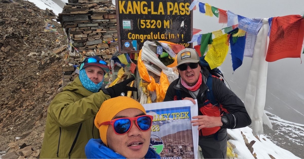
This geographic isolation kept the region closed to outsiders for centuries until the government opened it to tourism in 2002. Because the high mountains blocked western influences, the local people maintained an untouched Tibetan Buddhist culture. You will find ancient monasteries, chortens, and mani walls that look exactly as they did centuries ago. The local communities still practice traditional yak herding and high-altitude farming. Meanwhile, the trail eventually reconnects with civilization by crossing the high Kang La Pass and descending into Ngawal village. This descent from the 5,320 m pass is highly challenging and grueling, featuring steep slopes covered in loose, shifting scree that requires trekking poles and careful footwork.
To reach this remote valley, you will first land at the international airport in Kathmandu. From the capital city, you will drive toward the mountains to begin your journey. While this region requires special restricted area permits, you can now legally trek here as a solo traveler. You do not need a second trekking partner, but you must hire a licensed local guide to enter. This ensures your safety while you walk beneath the giant snow peaks of the Himalaya.
Why Understanding the Trek Map Makes the Journey Easier?
Studying the Nar Phu Valley Trek Map helps you visualize the daily walking distances and steep elevation gains before you step onto the trail. When you look at the map, you can identify exactly where the narrow river canyons open up into the high-altitude villages of Nar and Phu. This visual aid shows the strategic placement of acclimatization points, which are essential for safety before you attempt the high Kang La Pass at 5,320 m. To prevent altitude sickness here, trekkers must spend a mandatory rest day in Phu or Nar village, limit daily sleeping elevation gains to 500 meters, drink 4 to 5 liters of water daily, and carry Diamox.
map of nar phu valley trek
It is important to analyze the route ahead of time. You reduce uncertainty about the terrain and build confidence for the strenuous days ahead. A clear map also helps you avoid common planning mistakes, such as underestimating the physical demands of consecutive climbing days. It shows the precise locations of teahouses and checkpoints where your licensed local guide will present your restricted-area permits.
Because you can now legally solo trek this route without a second partner, having a firm grasp of the map ensures you stay oriented and informed. Furthermore, it prepares you for the local accommodation, which consists of basic, unheated teahouses with shared squat toilets and extra fees for hot bucket showers in Meta, Nar, and Phu. Ultimately, this preparation enhances your overall trekking experience and allows you to focus on the unique Tibetan culture around you.
How to read the trek map?
Reading a Nar Phu Valley Trek Map requires you to trace the line starting at Besisahar and moving along the Annapurna Circuit up to Koto. At Koto, you look for the trail that branches northeast into the deep, narrow canyons toward Meta, Nar, and Phu villages. You need to look for the specific symbols that mark acclimatization rest days, checkpoint gates, and the high Kang La Pass at 5,320 m before the route drops back down into Ngawal. Checking the contour lines tells you how steep the elevation gains are each day, which helps you pace yourself. Your licensed local guide will handle on-the-ground navigation, but tracking these map symbols helps you visualize the daily distances and pass crossings ahead of time.
Complete Nar Phu Valley Trek Route Explained
The Classic Short Nar Phu Valley Trek
The Classic Short Nar Phu Valley Trek delivers an uncrowded mountain journey north of the Annapurna Circuit. This specific route bypasses longer approach trails to focus directly on the high, stone-walled villages of Nar and Phu. You will experience ancient Tibetan communities that remained closed to the outside world for centuries. The trail challenges you with rugged river canyons and a major crossing over the steep Kang La Pass at 5,320 m.
Day
Route
Walking Hours
Distance (Approx.)
Difficulty
Elevation
Overnight
1
Kathmandu to Koto Via Besisahar
9-10 hours (Drive)
240 km (Drive)
Moderate
2,600 m
Koto
2
Koto to Meta
7 hours
16 km
Strenuous
3,560 m
Meta
3
Meta to Phu Village
7 hours
18 km
Strenuous
4,080 m
Phu Village
4
Phu Village to Nar Phedi
6 hours
15 km
Moderate
3,490 m
Nar Phedi
5
Nar Phedi to Nar Village
3 hours
6 km
Moderate
4,110 m
Nar Village
6
Nar Village to Kang La Pass to Ngawal
8 hours
17 km
Strenuous
3,660 m
Ngawal
7
Ngawal to Chame
5 hours
14 km
Moderate
2,670 m
Chame
8
Chame to Besisahar
4-5 hours (Drive)
65 km (Drive)
Moderate
760 m
Besisahar
9
Besisahar to Kathmandu
5-6 hours (Drive)
150 km (Drive)
Moderate
1,400 m
Kathmandu
The Complete Nar Phu Valley Circuit Adventure
The Classic Nar Phu Valley Trek combines the remote trails of a hidden valley with the high passes of the Annapurna Circuit. This journey leads you through narrow river canyons to the isolated stone villages of Nar and Phu near the Tibetan border. You will explore a deeply preserved Buddhist culture that remained closed to foreigners for centuries. The route demands strong physical fitness as you cross two major mountain passes: the Kang La Pass at 5,320 m and the Thorong La Pass at 5,416 m.
Day
Route
Walking Hours
Distance (Approx.)
Difficulty
Elevation
Overnight
1
Kathmandu to Chamje
8-9 hours (Drive)
180 km (Drive)
Gentle
1,410 m
Chamje
2
Chamje to Dharapani
5-6 hours
12 km
Moderate
1,860 m
Dharapani
3
Dharapani to Koto village
5-6 hours
15 km
Moderate
2,600 m
Koto
4
Koto to Meta
6-7 hours
14 km
Moderate
3,560 m
Meta
5
Meta to Phu Gaun
6-7 hours
18 km
Moderate
4,080 m
Phu Gaun
6
Phu Gaun to Nar Village
6-7 hours
16 km
Challenging
4,110 m
Nar Village
7
Explore Nar Village (Acclimatization)
0 hours
0 km
Moderate
4,110 m
Nar Village
8
Nar Village to Ngawal via Kang La Pass
8-9 hours
15 km
Challenging
3,660 m
Ngawal
9
Ngawal to Manang
4 hours
10 km
Challenging
3,540 m
Manang
10
Manang to Ledar
4-5 hours
11 km
Challenging
4,200 m
Ledar
11
Ledar to High Camp
4-5 hours
7 km
Challenging
4,850 m
High Camp
12
High Camp to Muktinath via Thorong La
8-9 hours
14 km
Challenging
3,760 m
Muktinath
13
Muktinath to Jomsom via Kagbeni
5-6 hours
19 km
Moderate
2,720 m
Jomsom
14
Fly from Jomsom to Pokhara
20 minutes (Flight)
—
Gentle
822 m
Pokhara
15
Drive from Pokhara back to Kathmandu
6-7 hours (Drive)
200 km (Drive)
Gentle
1,400 m
Kathmandu
The extended route: Annapurna Circuit with Nar Phu
thorong la pass annapurna circuit trek
The Annapurna Circuit with Nar Phu Valley and Tilicho trek combines the classic Annapurna Circuit with the rugged, restricted valleys of Nar and Phu. You leave the main trail at Koto to enter a landscape of deep gorges, ancient Tibetan villages, and high alpine pastures. It is a demanding route that requires excellent physical fitness. You will cross two major high passes, which increases the risk of altitude sickness if you do not acclimatize properly. The route rejoins the standard Annapurna Circuit at Ngawal after you cross the challenging Kang La Pass. From there, you head toward Manang and push up to Thorong La Pass, the highest point of the trek. This combination delivers a stark contrast between the hidden, medieval Tibetan culture of Nar Phu and the busier, teahouse-heavy main circuit.
Day
Route
Walking Hours
Distance (Approx.)
Difficulty
Elevation
Overnight
1
Kathmandu to Jagat via Besisahar
7-8 hours (Drive)
195 km (Drive)
Gentle
1,300 m
Jagat
2
Jagat to Dharapani
5–6 hours
15 km
Moderate
1,860 m
Dharapani
3
Dharapani to Koto
5–6 hours
15 km
Moderate
2,600 m
Koto
4
Koto to Meta
6-7 hours
14 km
Moderate
3,560 m
Meta
5
Meta to Phu Gaun
6-7 hours
18 km
Moderate
4,080 m
Phu Gaun
6
Phu Gaun to Nar Village
5–6 hours
16 km
Challenging
4,110 m
Nar Village
7
Explore Nar Village or Base Camp
0 hours
0 km
Moderate
4,110 m
Nar Village
8
Nar Village to Ngawal via Kang La Pass
8-9 hours
15 km
Challenging
3,660 m
Ngawal
9
Ngawal to Manang
3-4 hours
10 km
Easy
3,540 m
Manang
10
Manang Village to Tilicho Base Camp
6-7 hours
15 km
Challenging
4,150 m
Tilicho Base Camp
11
Trek to Tilicho Lake and Back to Siri Kharka
6-7 hours
12 km
Challenging
4,060 m
Siri Kharka
12
Siri Kharka to Ledar
4 to 5 hours
10 km
Moderate
4,200 m
Ledar
13
Ledar to High Camp
4–5 hours
7 km
Challenging
4,850 m
High Camp
14
High Camp to Muktinath via Thorong La Pass
8-9 hours
14 km
Challenging
3,760 m
Muktinath
15
Drive from Muktinath to Tatopani
4-5 hours (Drive)
75 km (Drive)
Moderate
1,200 m
Tatopani
16
Drive from Tatopani to Pokhara
4-5 hours (Drive)
100 km (Drive)
Gentle
822 m
Pokhara
17
Drive from Pokhara back to Kathmandu
7-8 hours (Drive)
200 km (Drive)
Gentle
1,400 m
Kathmandu
Major Villages and Landmarks on the Nar Phu Valley Trek
While navigating the Nar Phu Valley Trek, you will come across many villages and landmarks. Knowing these key stops along this restricted loop allows you to understand the terrain, prepare for big elevation shifts, and track your daily progress accurately.
Koto checkpoint
The small village of Koto sits at 2,600 m on the bustling Annapurna Circuit trek trail and serves as the official gateway to your wilderness adventure. This settlement holds a vital government police checkpoint where all foreign travelers must halt. Your licensed local guide will present your specialized Restricted Area Permit to the authorities for physical verification and logging. You cannot pass this gate alone or without legal agency documentation, making it the critical starting point of the restricted loop.
Meta
Leaving the main river valley behind, the trail climbs steeply through narrow stone gorges to reach the open pasture of Meta at 3,560 m. This high-altitude plateau offers your first clear view of the massive snow peaks of Pisang Himal. The landscape changes instantly from dense bamboo forest to dry alpine terrain dotted with juniper bushes. This village serves as a vital resting point, helping your lungs adjust to the thinner mountain air before you head deeper into the mountains toward the Tibetan border.
Phu village
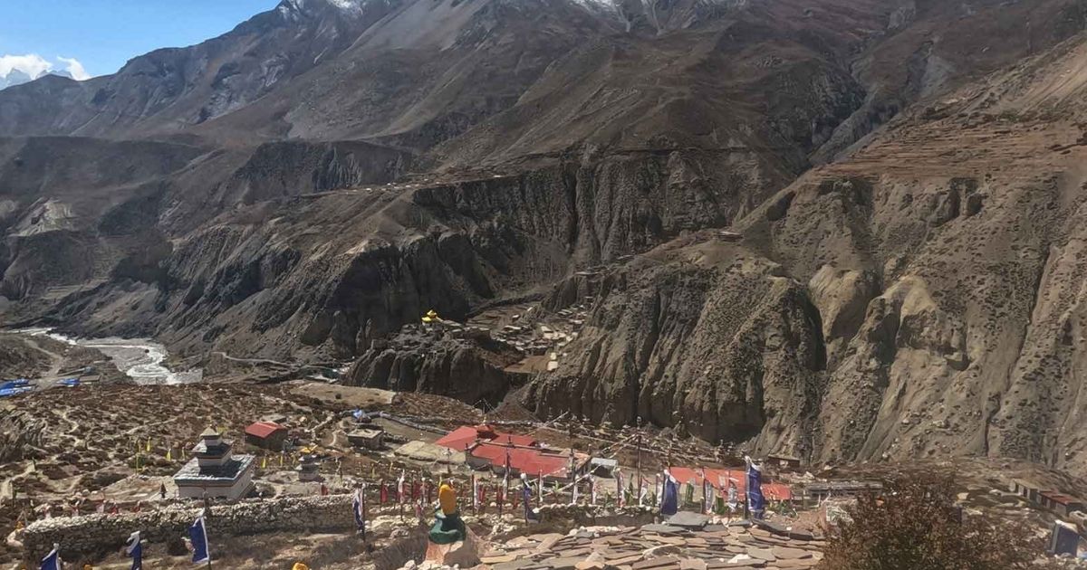
Phu Village from Monastery
The ancient stone settlement of Phu sits tucked inside a hidden canyon at an altitude of 4,080 m. The village features flat-roofed mud houses stacked directly onto the craggy hillside, looking exactly like a medieval Tibetan outpost. Local people here still live a traditional lifestyle centered around yak herding, high-altitude farming, and weaving woolen goods. The extreme geographic isolation kept this community completely closed to outsiders for centuries, preserving its unique traditions from modern development.
Nar Village
Nar village is located at 4,110 m and stands as a larger, livelier counterpart to the quiet neighborhood of Phu. The stone houses are built tightly together to block out the biting alpine winds, with winter firewood stacked neatly along the roof edges. You will notice a strong presence of Tibetan Buddhist culture here, with colorful prayer flags spinning above traditional stone chortens. This high settlement serves as your final launchpad, where you must sleep early and rest your muscles before tackling the pass.
Kang La Pass
kang la pass
The formidable crest of the Kang La Pass stands at 5,320 m and acts as the highest, most physically demanding point of your entire journey. Reaching the summit requires a slow, dark, pre-dawn climb up a steep and icy lateral moraine. But your hard work is rewarded at the top with a massive, close-up view of the Annapurna II peak and the surrounding glaciers. The trail then drops down a very long, steep scree slope, connecting the isolated northern valleys back to the main circuit at Ngawal.
Tashi Lhakhang Gompa
Perched on a rocky cliff above Phu village, the historic Tashi Lhakhang Gompa is a 600-year-old Buddhist monastery. This sacred site is widely considered one of the oldest active monasteries in the entire Manang District. Inside the dark, incense-filled halls, you will find ancient statues, colorful religious paintings, and sacred scrolls preserved by local monks. Visiting this spiritual outpost allows you to sit with the resident monks and experience the deep religious heritage that guides daily life in the valley.
Ready to Explore the Nar Phu Valley Route?
Follow the trail from Koto through Meta, Phu, Nar, and across the spectacular Kang La Pass. Explore the Nar Phu Valley Trek itinerary, route, altitude, and essential trip details.
Understanding the elevation changes along your mountain route helps keep you safe from altitude sickness. The trail inside this restricted northern enclave climbs rapidly from the dense forests of Koto directly into thin alpine air. You must plan your physical pacing around specific rest landmarks to let your body adjust safely. But tracking these shifts becomes straightforward when you use a calculated elevation profile.
The trek structures your journey to ensure a safe, gradual ascent before you tackle the highest points. You will spend crucial nights at intermediate altitudes, such as Meta and Nar Phedi, to build red blood cells. This strict acclimatization strategy minimizes the risk of acute mountain sickness (AMS) before you push toward the pass's extreme altitude.
Trekking Stage
Starting Altitude
Ending Altitude
Net Elevation Change
Acclimatization Status
Koto to Meta
2,600 m
3,560 m
+960 m
First major altitude shift
Meta to Phu Village
3,560 m
4,080 m
+520 m
Entry into the extreme alpine zone
Phu Village Exploration
4,080 m
4,080 m
0 m
Mandatory rest and adaptation day
Phu Village to Nar Phedi
4,080 m
3,490 m
-590 m
Recovery descent to rest your lungs
Nar Phedi to Nar Village
3,490 m
4,110 m
+620 m
Final staging point for the pass
Nar Village to Kang La Pass
4,110 m
5,320 m
+1,196 m
The highest point of the entire trek
Kang La Pass to Ngawal
5,320 m
3,660 m
-1,646 m
Rapid descent to a safe lower altitude
How does Nar Phu connect to the Annapurna Circuit?
The Nar Phu Valley connects to the Annapurna Circuit as a hidden mountain loop that branches off and rejoins the main trail at two distinct locations. You begin the journey on the classic circuit trail, traveling past the lower foothills to reach the small village of Koto. At Koto, you leave the busy Marsyangdi River valley behind and turn northeast into the narrow, restricted river canyons. The path then leads you deep into the isolated high-altitude settlements of Nar and Phu near the Tibetan border, completely away from modern road networks.
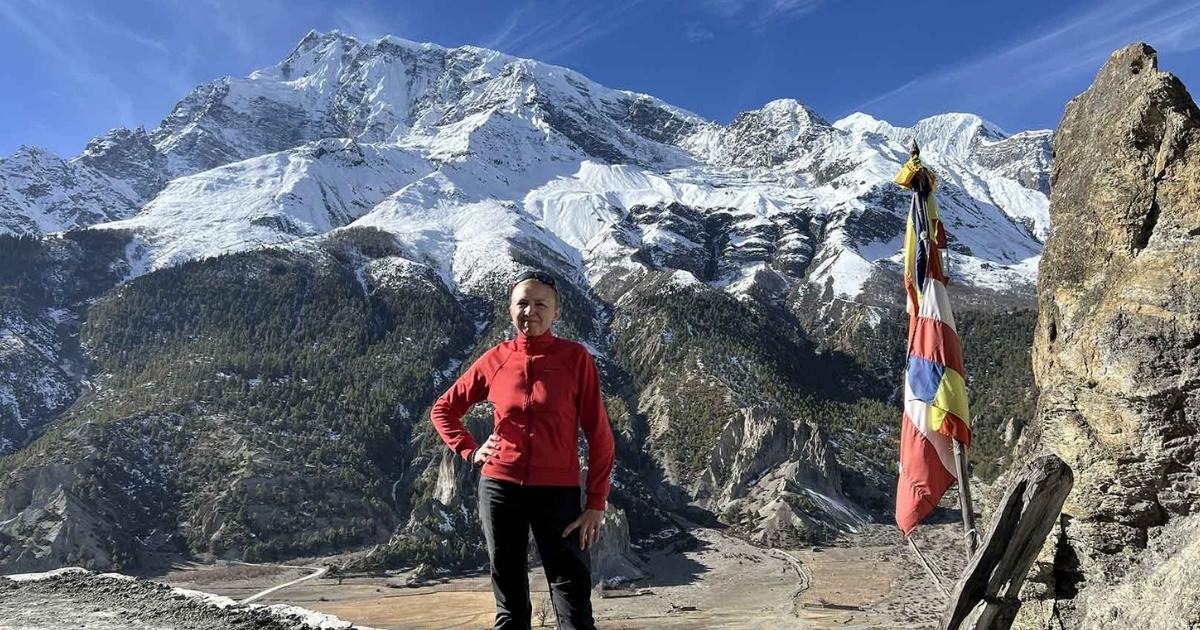
Manang Valley with the majestic Annapurna mountain range
But your journey inside the restricted valley eventually arcs back to meet the standard trekking route. After exploring the ancient villages, you climb out of the northern basin to tackle the steep lateral moraine of the Kang La Pass at 5,320 m. Crossing this formidable high pass brings you over the mountain wall and drops you down a long, rocky scree slope directly into the wide Manang Valley. The trail finishes its loop by rejoining the main Annapurna Circuit at the historic stone village of Ngawal, allowing you to either continue onward to Thorong La Pass or head down toward Chame.
Permits and Restricted-area entry/exit points
To trek legally in the Nar Phu Valley, you must obtain two distinct permits, which are the Restricted Area Permit and the Annapurna Conservation Area Permit.
1. Restricted Area Permit (RAP): This is the primary permit required for the Nar Phu Valley. The fee varies based on the season:
Peak Season (September – November): USD 100 per person for the first 7 days, plus USD 15 per person/day for any extra days spent within the restricted zone.
Off-Peak Season (December – August): USD 75 per person for the first 7 days, plus USD 15 per person/day (or USD 10/day depending on precise immigration adjustment) for extra days.
2. Annapurna Conservation Area Permit (ACAP): Mandatory as Nar Phu lies within the protected conservation zone. It costs NPR 3,000 (approx. USD 23–30) per person. It features no seasonal price variations and is valid for a single entry for the duration of your trek.
Restricted Area Entry & Exit Points
The boundaries of the Nar Phu restricted zone are strictly monitored at physical checkpoints.
Official Entry Point: Koto. Trekkers leave the main Annapurna Circuit trail at Koto (just before Chame) to branch north into the Nar Phu gorge. Your RAP will be physically checked and logged at the Koto police check-post.
Internal Checkpoint: Meta (or Kyang village, where administrative offices operate). This serves as the secondary verification point deeper inside the valley.
Official Exit Point: Kang La Pass (5,320m). The restricted zone ends once you cross the high Kang La Pass and descend back into Ngawal / Manang, rejoining the standard, unrestricted Annapurna Circuit.
Best Time to Use the Nar Phu Valley Trek Map
The best time to use the Nar Phu Valley Trek Map is during the peak trekking windows of spring, from March to May, and autumn, from September to November. During these months, dry weather and clear morning skies offer the safest conditions to navigate the steep terrain and the high Kang La Pass at 5,320 m. You can use the map to cross-reference daily walking routes with seasonal trail updates: identifying seasonal water sources, open teahouses, and active police checkpoints. But tracking the route on paper becomes especially critical in early spring when late-season snow can obscure high-altitude markers near the pass.
Also, studying the map ahead of time helps you avoid major weather hazards, such as the heavy monsoon rains from June to August. The map highlights narrow river gorges between Koto and Meta that are highly prone to sudden landslides and rockfalls during wet months. Meanwhile, winter trekking from December to February brings extreme freezing temperatures and deep snow that regularly blocks the high pass entirely. By aligning your map study with the stable autumn or spring seasons, you ensure your scheduled acclimatization stops match real-world trail accessibility.
Need a Nar Phu Trek Route That Fits Your Plans?
Want to adjust the trekking days, route, or pace? Get a Nar Phu Valley trek plan tailored to your travel dates, fitness level, and preferred itinerary.
The Nar Phu Valley Trek is considered strenuous, requiring high levels of physical fitness and strong mental endurance. You will hike through rugged, steep terrain for multiple consecutive days at elevations well above 4,000 m. The thin alpine air makes standard walking much more difficult and puts extra strain on your cardiovascular system. But tracking your physical pacing becomes manageable when you plan your rest days carefully. The most grueling portion of the loop is the crossing of the Kang La Pass at 5,320 m, where you face a steep climb over loose scree and ice.
Way to Phu Village
Safety on this remote trail depends entirely on proper acclimatization and compliance with the law. Altitude sickness is a real danger, so you must watch for early symptoms like headaches or dizziness. While recent policy changes allow you to solo trek this restricted region without a second traveler, you must hire a licensed local guide. A professional guide is mandatory for navigation, monitoring your health, and clearing your paperwork at mountain checkpoints. Meanwhile, your travel insurance must specifically cover emergency helicopter evacuation up to 6,000 m, as there are no advanced medical clinics in the valley.
The Nar Phu Valley Trek Map serves as your ultimate guide to navigating one of the most culturally isolated regions of north-central Nepal. By mapping your daily elevation milestones and tracking the rugged terrain from Koto to the high mountain pass, you eliminate guesswork and significantly reduce your risk of altitude sickness. This detailed geographical overview ensures you stay on course as you explore ancient Tibetan Buddhist enclaves and cross the formidable Kang La Pass at 5,320 m. With recent policy updates allowing solo travelers to legally access this restricted zone with a mandatory licensed guide, having a reliable route map gives you the confidence to execute a flawless alpine journey.
Contact our team at Nature Excursion today to secure your mandatory guide and restricted area permits for the upcoming trekking season.
Written by
Raju GurungMD
Gurung is the founder and managing director of ‘Nature Excursion Pvt. Ltd.’ The mountains and hills from his village, Rubi Valley, always had him wondering, and he became one of the travel enthusiasts from his early childhood.
The main autumn treks in Nepal are Everest Base Camp, the Annapurna Circuit, Annapurna Base Camp, the Manaslu Circuit, Langtang Valley, and Mardi Hima...
To choose the best trekking company in Nepal, you must verify that the agency holds official registration with the Nepal Ministry of Culture, Tourism...
Sagarmatha National Park is one of Nepal’s most famous protected areas and the core of the Everest region. Located in the high Himalayas of Solukhumbu...






.webp)

.webp)
.webp)